About Haryana
Area of Haryana: 44,212 sq km. Population: 2,10,83,000 (2001 Census) Latitude: 27 deg 37' to 30 deg 35' Longitude: between 74 deg 28' to 77 deg 36' Altitude: between 700 to 3600 ft above sea level. Climate: highest 50 deg Celsius; lowest 1 deg Celsius.
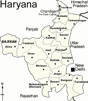
Haryana is a small state in nothern India. It has a total of 81 cities and towns. It has 6,759 villages. For administrative purpose the state is divided into four divisions - Ambala, Rohtak, Gurgaon and Hissar. There are 19 districts, 47 sub-divisions, 67 tehsils, 45 sub-tehsils and 116 blocks. Haryana is situated in the north between 27 deg 37' to 30 deg 35' latitude and between 74 deg 28' to 77 deg 36' longitude. Haryana has Uttar Pradesh (UP) on its eastern border, Punjab on its western border, Uttranchal, Himachal Pradesh & Shivalik Hills on its northern border and Delhi, Rajasthan and Aravali Hills on its southern border. The altitude of Haryana varies between 700 ft to 900 ft above the sea level. An area of 1,553 sq km is covered by forest
The hottest months are May and June and the coldest being December and January. Rainfall is varied, with Shivalik Hills region being the wettest and the Aravali Hills region being the driest. About 80% of the rainfall occurs in the monsoon season (July-September) and sometimes causes local flooding.
How to get here...
Transport System: The main transport systems in Haryana are Roads and Railway.
By Air
Nearest airport is in the capital Chandigarh.(250 Kms from Sirsa) Indian Airlines connect Chandigarh with Delhi, Jammu, Shrinagar and Leh. Vayudoot Services connect Chandigarh with Delhi, Kulu and Gaggad.
Roads: Haryana has a total length of 29,524 kilometers of paved (metalled) roads; making it one of the most well connected states in whole of Asia. Every village of the state is now linked with paved roads. The length of the national highways passing through Haryana is 665 km. The following five national highways pass through Haryana.
1. National Highway 1 (NH1) Delhi - Karnal - Kurukshetra - Ambala - Amritsar. Famous as the GT Road.
2. National Highway 10 (NH10) Delhi - Rohtak - Hansi - Hissar - Fatehbad - Sirsa - Ferozepur.
3. National Highway 21 (NH21) Chandigarh - Panchkula - Pinjore - Kalka - Shimla.
4. National Highway 2 (NH2) Delhi - Faridabad - Mathura - Agra - Mumbai (Bombay)
5. National Highway 8 (NH8) Delhi - Gurgaon - Jaipur - Mumbai (Bombay)
Haryana Roadways: The total number of buses plied by Haryana Roadways is 3,411. There are a total of 82 Bus Stands and 20 Bus Depots.
Railway System: Haryana is well connected on the rail network. Under the National Capital Region (NCR) scheme there is already a proposal to provide rail corridor connecting towns around Delhi linking the major satellite towns like Faridabad, Gurgaon, Kundli, Bahadurgarh etc. The main railway routes passing through Haryana are:
Amritsar - Delhi
Rewari - Ahemdabad
Bhiwani - Rohtak-Delhi
Ambala - Ferozepur
Delhi - Ferozepur
Kalka - Jodhpur
Kalka - Howrah
Amritsar - Howrah
Delhi - Shimla